Czisilia: Difference between revisions
Jump to navigation
Jump to search
Content added Content deleted
imported>Rox mNo edit summary |
imported>Rox No edit summary |
||
| Line 15: | Line 15: | ||
|other_symbol_type = <!--Use if a further symbol exists, e.g. hymn--> |
|other_symbol_type = <!--Use if a further symbol exists, e.g. hymn--> |
||
|other_symbol = |
|other_symbol = |
||
| − | |image_map = |
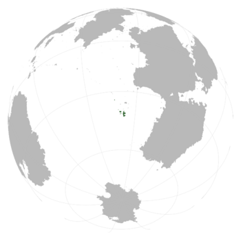
+ | |image_map = Czisilia-locator.png |
|alt_map = <!--alt text for map--> |
|alt_map = <!--alt text for map--> |
||
| − | |map_caption = |
+ | |map_caption = Czisilia (dark green) on Jotunnheim |
|image_map2 = <!--Another map, if required--> |
|image_map2 = <!--Another map, if required--> |
||
|alt_map2 = <!--alt text for second map--> |
|alt_map2 = <!--alt text for second map--> |
||
| Line 58: | Line 58: | ||
|area_magnitude = |
|area_magnitude = |
||
|area = <!--Major area size (in [[Template:convert]] either km2 or sqmi first)--> |
|area = <!--Major area size (in [[Template:convert]] either km2 or sqmi first)--> |
||
| − | |area_km2 = |
+ | |area_km2 = 86062 |
|area_sq_mi = <!--Area in square mi (requires area_km2)--> |
|area_sq_mi = <!--Area in square mi (requires area_km2)--> |
||
|area_footnote = <!--Optional footnote for area--> |
|area_footnote = <!--Optional footnote for area--> |
||
| Line 65: | Line 65: | ||
|area_label2 = <!--Label below area_label (optional)--> |
|area_label2 = <!--Label below area_label (optional)--> |
||
|area_data2 = <!--Text after area_label2 (optional)--> |
|area_data2 = <!--Text after area_label2 (optional)--> |
||
| − | |population_estimate = |
+ | |population_estimate = 4,036,000 |
|population_estimate_rank = |
|population_estimate_rank = |
||
| − | |population_estimate_year = |
+ | |population_estimate_year = 4627 CY |
|population_census = |
|population_census = |
||
|population_census_year = |
|population_census_year = |
||
| − | |population_density_km2 = |
+ | |population_density_km2 = 46.9 |
|population_density_sq_mi = |
|population_density_sq_mi = |
||
|population_density_rank = |
|population_density_rank = |
||
Revision as of 06:26, 2 July 2022
Holy Realms of Czisilia and the Lhidian Dominion Çisil | |
|---|---|
Motto: "The glory of our Fathers" | |
 Czisilia (dark green) on Jotunnheim | |
| Capital and | Eresa |
| Official languages | Czisilian |
| Recognised national languages | Lhidian |
| Demonym(s) | Czisilian, Czisil |
| Government | Unitary parliamentary theocracy |
• Chaek | Kholiw the Resplendent |
• Head of the Apparatus | Alep Yĕşam |
| Legislature | The Apparatus |
| Area | |
• | 86,062 km2 (33,229 sq mi) |
| Population | |
• 4627 CY estimate | 4,036,000 |
• Density | 46.9/km2 (121.5/sq mi) |
Czisilia (/t͡ʃɪˈsɪlɪjə/; Czisilian: Çisil, [ˈt͡ɕɪ.sɪl]), officially the Holy Realms of Czisilia and the Lhidian Dominion (Czisilian: X), is a sovereign state located in Milevia.
Etymology
The name Czisilia comes from the Proto-South Milevic name *t͡ɬis-ahhil, meaning "land of travelers". This name was originally used to refer to the general Southern Milevic area, due to the southern Milevic clans being merchants.

