Pachayanid Empire: Difference between revisions
Jump to navigation
Jump to search
Content added Content deleted
mNo edit summary |
mNo edit summary |
||
| (4 intermediate revisions by the same user not shown) | |||
| Line 61: | Line 61: | ||
|s5 = |
|s5 = |
||
|flag_s5 = |
|flag_s5 = |
||
| − | |image_flag = <!-- Default: Flag of {{{common_name}}}.svg --> |
+ | |image_flag = Standard of Pachayan the Great.png <!-- Default: Flag of {{{common_name}}}.svg --> |
|flag_alt = <!-- Alt text for flag --> |
|flag_alt = <!-- Alt text for flag --> |
||
|image_flag2 = <!-- Second flag --> |
|image_flag2 = <!-- Second flag --> |
||
| Line 67: | Line 67: | ||
|flag = <!-- Link target under flag image. Default: Flag of {{{common_name}}} --> |
|flag = <!-- Link target under flag image. Default: Flag of {{{common_name}}} --> |
||
|flag2 = <!-- Link target under flag2 image. Default: Flag of {{{common_name}}} --> |
|flag2 = <!-- Link target under flag2 image. Default: Flag of {{{common_name}}} --> |
||
| − | |flag_type = <!-- Displayed text for link under flag. Default "Flag" --> |
+ | |flag_type = Standard of [[Pachayan the Great]] <!-- Displayed text for link under flag. Default "Flag" --> |
|flag2_type = <!-- Displayed text for link under flag2. Default "Flag" --> |
|flag2_type = <!-- Displayed text for link under flag2. Default "Flag" --> |
||
|image_coat = <!-- Default: Coat of arms of {{{common_name}}}.svg --> |
|image_coat = <!-- Default: Coat of arms of {{{common_name}}}.svg --> |
||
| Line 76: | Line 76: | ||
|image_map = File:First-eran-empire-map.png |
|image_map = File:First-eran-empire-map.png |
||
|image_map_alt = |
|image_map_alt = |
||
| − | |image_map_caption = The Pachayanid Empire at its greatest territorial extent, under the rule of Name I ( |
+ | |image_map_caption = The Pachayanid Empire at its greatest territorial extent, under the rule of Name I (ca. 1860 CY) |
|image_map2 = <!-- If second map is needed; does not appear by default --> |
|image_map2 = <!-- If second map is needed; does not appear by default --> |
||
|image_map2_alt = |
|image_map2_alt = |
||
| Line 96: | Line 96: | ||
|leader4 = |
|leader4 = |
||
|leader21 = <!--(up to 21 distinct leaders may be included)--> |
|leader21 = <!--(up to 21 distinct leaders may be included)--> |
||
| − | |year_leader1 = 1717 – |
+ | |year_leader1 = 1717 – 1751 CY<!-- Years served --> |
|year_leader2 = |
|year_leader2 = |
||
|year_leader3 = |
|year_leader3 = |
||
| Line 144: | Line 144: | ||
|stat_area5 = |
|stat_area5 = |
||
|stat_pop5 = |
|stat_pop5 = |
||
| + | |today = {{Collapsible list |
||
| − | |today = {{flag|Eran}}<br>{{flag|Sakhasta}}<br>{{flag|Menkhemon}}<br>{{flag|Teshkasta}}<!-- Present-day countries that overlap with the territorial extent of the former country. Do not use this parameter if there are more than four such countries. --><!-- Do NOT add flags, per MOS:INFOBOXFLAG --> |
||
| + | | title = List |
||
| + | | list_style = text-align:left; |
||
| + | | 1 = [[Azalchet]] | 2 = [[Eran]] | 3 = [[Is Teru]] | 4 = [[Jashakar]] | 5 = [[Menkhemon]] | 6 = [[Nözhya]] | 7 = [[Sakhasta]] | 8 = [[Teshkasta]] | 9 = [[Wahakkum]] | 10 = [[Yarami and Kitaku]] |
||
| + | }} |
||
|footnote_a = <!-- Accepts wikilinks --> |
|footnote_a = <!-- Accepts wikilinks --> |
||
|footnote_b = <!-- Accepts wikilinks --> |
|footnote_b = <!-- Accepts wikilinks --> |
||
Latest revision as of 09:18, 8 March 2025
Pachayanid Empire Partā | |||||||||
|---|---|---|---|---|---|---|---|---|---|
| 1717 CY–2074 CY | |||||||||
|
Standard of Pachayan the Great | |||||||||
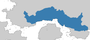
 The Pachayanid Empire at its greatest territorial extent, under the rule of Name I (ca. 1860 CY) | |||||||||
| Common languages | High Angkat
See: Languages | ||||||||
| Government | Monarchy | ||||||||
| King | |||||||||
• 1717 – 1751 CY | Pachayan the Great | ||||||||
| History | |||||||||
• Established | 1717 CY | ||||||||
• Fall | 2074 CY | ||||||||
| |||||||||
| Today part of | |||||||||
The Pachayanid Empire (High Angkat: Partā, lit. 'The Nation') was an ancient empire founded by Pachayan the Great in 1717 CY, also known as the First Eran Empire.
