Tuustschuschuun: Difference between revisions
Jump to navigation
Jump to search
Content added Content deleted
No edit summary |
No edit summary |
||
| (2 intermediate revisions by the same user not shown) | |||
| Line 1: | Line 1: | ||
{{Infobox country |
{{Infobox country |
||
|conventional_long_name = County of Tuustschuschuun <!--Formal or official full name of the country in English--> |
|conventional_long_name = County of Tuustschuschuun <!--Formal or official full name of the country in English--> |
||
| − | |native_name = <!--Country's name (usually full name) in its native language, hence in italics (double quotemarks)--> |
+ | |native_name = {{cs|dhm|kæn-rós-tyz-chy-shýn}}<br>''Kaanrööss Tustschuschuun''<!--Country's name (usually full name) in its native language, hence in italics (double quotemarks)--> |
|common_name = Tuustschuschuun <!--Common name in English (used for wiki links and to produce a default iso3166 code)--> |
|common_name = Tuustschuschuun <!--Common name in English (used for wiki links and to produce a default iso3166 code)--> |
||
|image_flag = Flag-Tuustschuschuun.png <!--e.g. Flag of country.svg--> |
|image_flag = Flag-Tuustschuschuun.png <!--e.g. Flag of country.svg--> |
||
| Line 61: | Line 61: | ||
|area_magnitude = |
|area_magnitude = |
||
|area = <!--Major area size (in [[Template:convert]] either km2 or sqmi first)--> |
|area = <!--Major area size (in [[Template:convert]] either km2 or sqmi first)--> |
||
| − | |area_km2 = <!--Major area size (in square km)--> |
+ | |area_km2 = 5534.9021 <!--Major area size (in square km)--> |
|area_sq_mi = <!--Area in square mi (requires area_km2)--> |
|area_sq_mi = <!--Area in square mi (requires area_km2)--> |
||
|area_footnote = <!--Optional footnote for area--> |
|area_footnote = <!--Optional footnote for area--> |
||
| Line 71: | Line 71: | ||
|population_estimate_rank = |
|population_estimate_rank = |
||
|population_estimate_year = |
|population_estimate_year = |
||
| − | |population_census = |
+ | |population_census = 758,282 |
|population_census_year = |
|population_census_year = |
||
| − | |population_density_km2 = |
+ | |population_density_km2 = 137 |
|population_density_sq_mi = |
|population_density_sq_mi = |
||
|population_density_rank = |
|population_density_rank = |
||
Latest revision as of 19:59, 13 November 2025
County of Tuustschuschuun kæn-rós-tyz-chy-shýn Kaanrööss Tustschuschuun | |
|---|---|
|
Flag | |
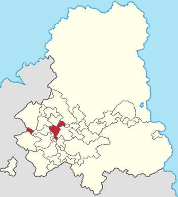
 Location of Tuustschuschuun in the Gintem Confederation | |
| Capital | X |
| Official languages | Tschintierst |
| Demonym(s) | Tuustschuschuuni |
| Government | Monarchy |
| State in the Gintem Confederation | |
| Area | |
• | 5,534.9021 km2 (2,137.0376 sq mi) |
| Population | |
• Census | 758,282 |
• Density | 137/km2 (354.8/sq mi) |
