Vöötschüpe: Difference between revisions
Jump to navigation
Jump to search
Content added Content deleted
No edit summary |
No edit summary |
||
| Line 1: | Line 1: | ||
{{Infobox country |
{{Infobox country |
||
|conventional_long_name = County of Vöötschüpe <!--Formal or official full name of the country in English--> |
|conventional_long_name = County of Vöötschüpe <!--Formal or official full name of the country in English--> |
||
| − | |native_name = <!--Country's name (usually full name) in its native language, hence in italics (double quotemarks)--> |
+ | |native_name = {{cs|dhm|kæn-rós-fó-chy-pe}}<br>''Kaanrööss Vöötschüpe''<!--Country's name (usually full name) in its native language, hence in italics (double quotemarks)--> |
|common_name = Vöötschüpe <!--Common name in English (used for wikilinks and to produce a default iso3166 code)--> |
|common_name = Vöötschüpe <!--Common name in English (used for wikilinks and to produce a default iso3166 code)--> |
||
|image_flag = Flag-Vooetschuepe.png <!--e.g. Flag of country.svg--> |
|image_flag = Flag-Vooetschuepe.png <!--e.g. Flag of country.svg--> |
||
Latest revision as of 20:02, 13 November 2025
County of Vöötschüpe kæn-rós-fó-chy-pe Kaanrööss Vöötschüpe | |
|---|---|
|
Flag | |
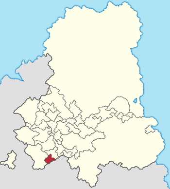
 Location of Vöötschüpe in the Gintem Confederation | |
| Capital | X |
| Official languages | Tschintierst |
| Demonym(s) | Vöötschüp |
| Government | Monarchy |
| State in the Gintem Confederation | |
| Area | |
• | 2,247.2506 km2 (867.6683 sq mi) |
| Population | |
• Census | 94,385 |
• Density | 42/km2 (108.8/sq mi) |
