Tschåvmurnoo: Difference between revisions
Jump to navigation
Jump to search
Content added Content deleted
No edit summary |
No edit summary |
||
| Line 1: | Line 1: | ||
{{Infobox country |
{{Infobox country |
||
|conventional_long_name = County of Tschåvmurnoo<!--Formal or official full name of the country in English--> |
|conventional_long_name = County of Tschåvmurnoo<!--Formal or official full name of the country in English--> |
||
| − | |native_name = <!--Country's name (usually full name) in its native language, hence in italics (double quotemarks)--> |
+ | |native_name = {{cs|dhm|kæn-rós-chf-myr-nó}}<br>''Kaanrööss Tschåvmurnoo''<!--Country's name (usually full name) in its native language, hence in italics (double quotemarks)--> |
|common_name = Tschåvmurnoo <!--Common name in English (used for wiki links and to produce a default iso3166 code)--> |
|common_name = Tschåvmurnoo <!--Common name in English (used for wiki links and to produce a default iso3166 code)--> |
||
|image_flag = <!--e.g. Flag of country.svg--> |
|image_flag = <!--e.g. Flag of country.svg--> |
||
Latest revision as of 19:54, 13 November 2025
County of Tschåvmurnoo kæn-rós-chf-myr-nó Kaanrööss Tschåvmurnoo | |
|---|---|
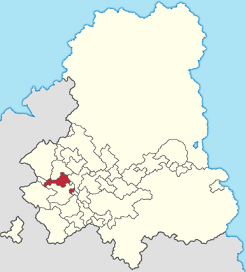
 Location of Tschåvmurnoo in the Gintem Confederation | |
| Capital | X |
| Official languages | Tschintierst |
| Demonym(s) | Tschåvmurnoon |
| Government | Monarchy |
| State in the Gintem Confederation | |
| Area | |
• | 3,927.587 km2 (1,516.450 sq mi) |
| Population | |
• Census | 365,266 |
• Density | 93/km2 (240.9/sq mi) |